South Kerry Development Partnership Ltd (SKDP) is a local area Development company, established in May 1991 to promote and support the Development of sustainable and vibrant communities in the south Kerry area. The South Kerry Walks is promoted by the South Kerry Development Partnership Limited and Failte Ireland.
Walks Scheme supports landowners along National way marked ways (in Kerry –The Kerry Way and SKDP sections of the Beara Way) to maintain the sections of the way marked ways on their lands by providing for a small payment in return for which each landowner undertakes necessary maintenance work.
South Kerry Development Partnership Ltd employs a Rural Recreation officer to work with Communities and Individuals to develop, oversee, maintain and promote Trails and Walks in South Kerry. South Kerry Development Partnership Ltd in conjunction with Failte Ireland work to promote these walks for communities and visitors alike by ensuring that they are of a high standard and accessible at all time.
We would acknowledge Failte Ireland for their contribution to the Walks and for the beautiful photo’s supplied.
Listed below are Walks and Trails along with Routes that have been developed, maintained and promoted by this scheme. We hope you enjoy these and keep and eye out for our updated walks on Facebook.
The Kerry Way Trail Section Descriptions/Routes
Distance: 24 km
Time: 6 – 8 hours
Difficulty: Moderate
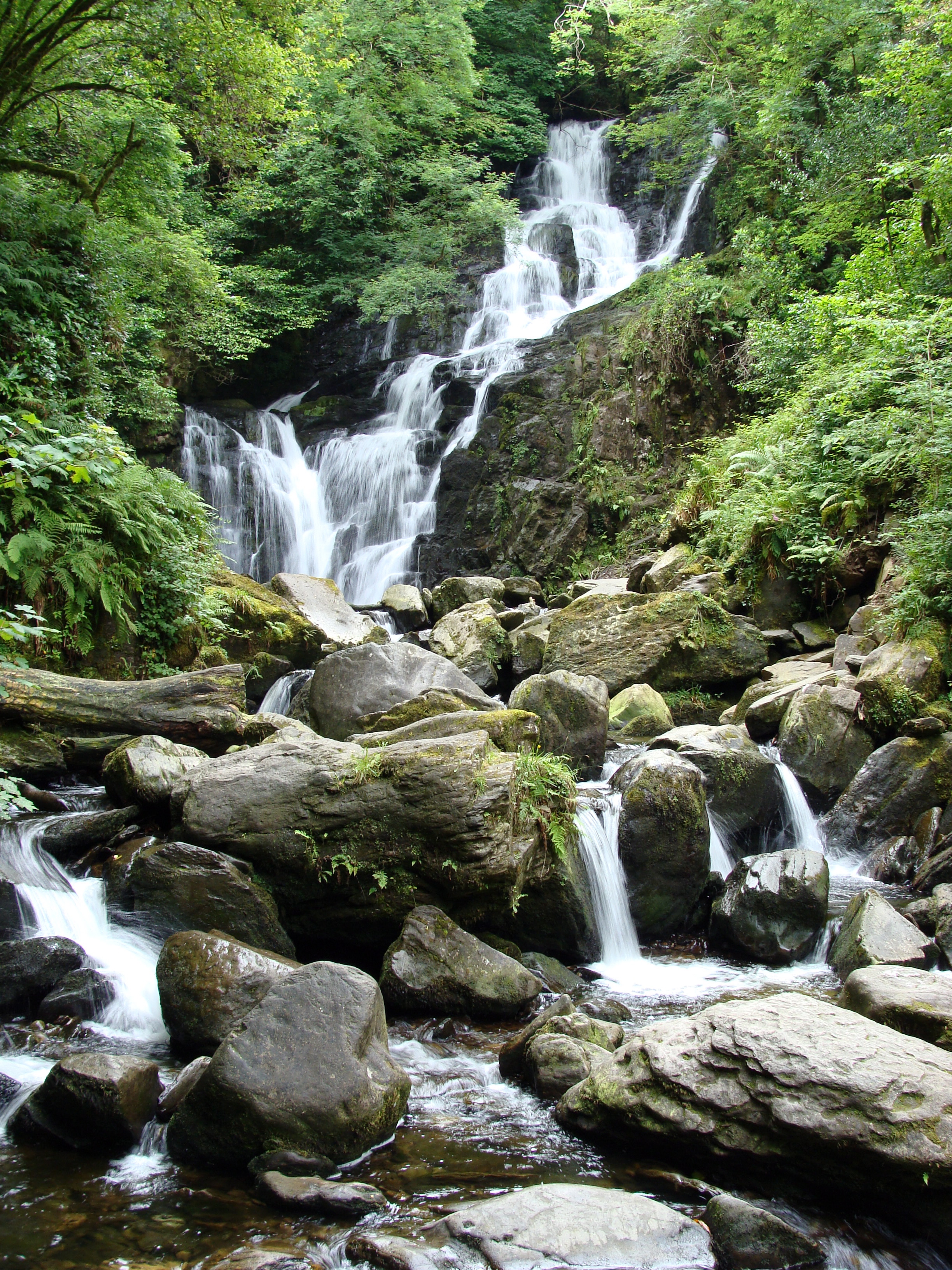
Highlights: Muckross House, Torc Waterfall, Owengarriff River, Esknamucky Glen and scenery between Peakeen and Knockanaguish Mountains
Terrain: mix of forest path, old coach road, rough track and roadway
Brief Description:
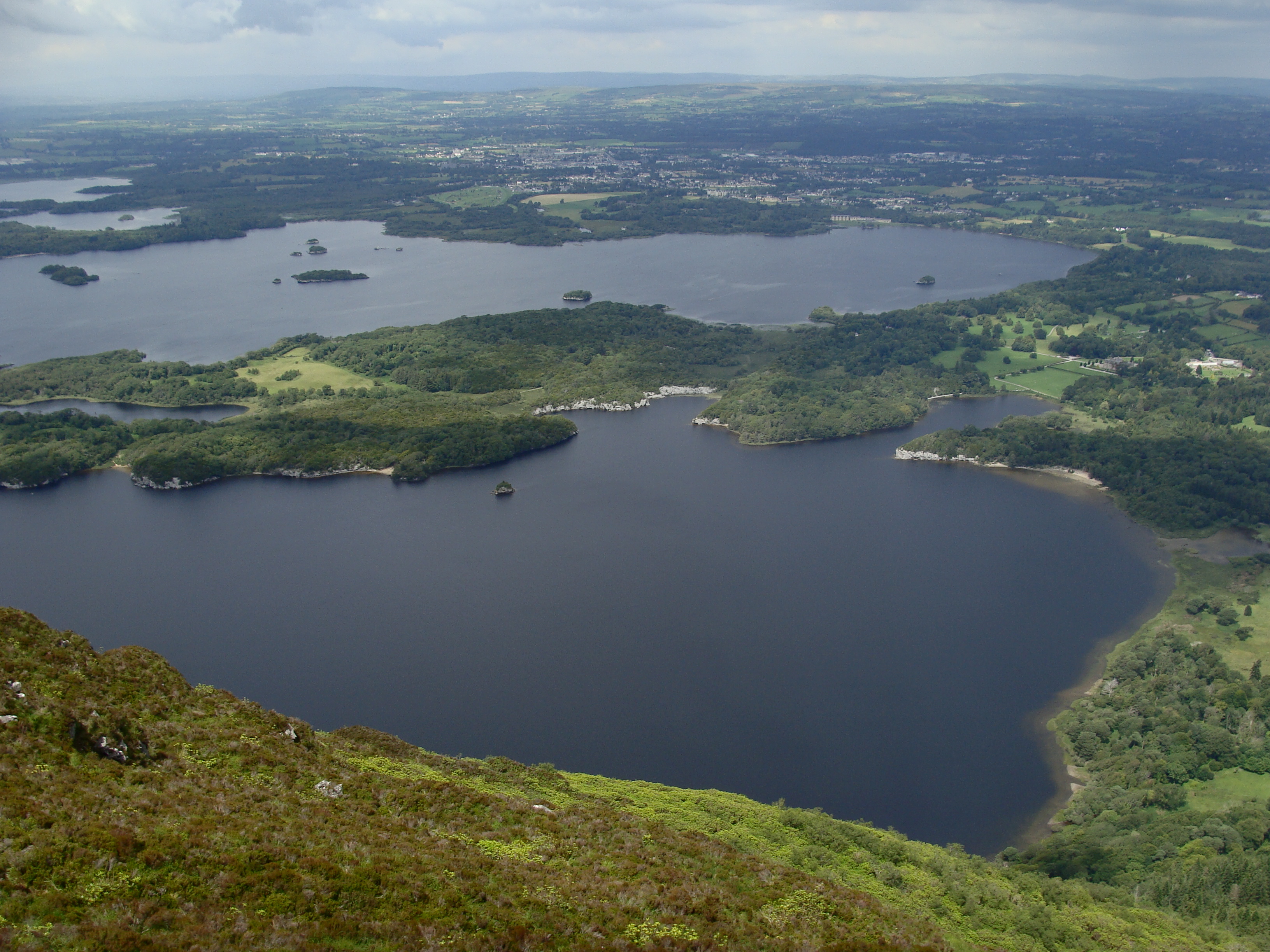
This section of the Kerry Way leaves the popular tourist town of Killarney, enters the Killarney National Park passing by Muckross House. The trail brings visitors to Torc Waterfall, one of Ireland’s most popular tourist attractions, before climbing along the Old Kenmare Road and providing spectacular views of the Macgillycuddy’s Reeks. The trail enters into the stunning Esknamucky Glen, crosses Galway’s River and continues up to a saddle between Peakeen and Knockahaguish Mountains. Fantastic views of the Kenmare River and Beara Peninsula open up before descending into the town of Kenmare.
Detailed (step-by-step) description:
Leave Killarney town following Muckross road. Cross over River Flesk. Mountains come into view. Follow along a lovely stonewall. Pass by several hotels, Caravan Park and petrol station with a Spar. Veer right and enter Killarney National Park. Continue beneath tree canopy. Reach open field and take right and follow footpath along Castlelough Bay and Lough Leane. Follow signs to the right. Trail hugs lake. Intersects with old road and continue straight towards Muckross House. Or you can follow the footpath on the left to Muckross House. Both the path and road go to Muckross House. Jaunting cars follow road sections so if you want less traffic take the footpath.
Reach Muckross House. Jaunting cars and horses parked here. Take right and follow signs for Torc Waterfall (2km). Continue on road/trail heading towards Muckross Lake. At next road/trail junction, you can either take footpath to the left or stay straight on road. Footpath takes you away from horses and carriages. Both routes meet up in 100 meters or so. Pass beside a 400-year-old cedar tree. Follow signs for Torc Waterfall. Continue through the thick forest of flowering rhododendron. Reach open field beneath Torc Mountain. There are great views looking up at Torc Mountain and eventually views of the Muckross Lake. Stay to the left and follow signs for waterfall.
Take footpath to the left (or stay straight on road). Footpath takes you away from horses and carriages. Follow signs for Torc Waterfall. Lovely walk among the flowering rhododendron. Reach open field beneath Torc Mountain. There are great views looking up at Torc Mountain and eventually views of the Muckross Lake. Stay to the left and follow signs for waterfall.
Cross through stone tunnel/bridge under N71 and head towards the sound of rushing water. Pass by parking area and toilet facilities. Eventually reach Torc Waterfall. It is easy to see why Torc Waterfall is one of Ireland’s best visitor attractions. It is a stunning waterfall. The Owengariff River cascades eighteen meters down rock and beneath the lush forest. It is a great spot for a picture.
Leave the waterfall heading up the many stone steps. Views back at the Muckross Lake. Reach trail junction of loop walks. Head left and then right. Follow old road and enter a Wildlife Refuge. Follow Owengariff River and eventually cross the river on bridge and reach trail junction. The Kerry Way continues to the left and heads towards Kenmare and Black Valley. Take left and continue through the trees. The trail leaves the forest canopy and continues across open terrain. Pass by Torc Mountain trail that takes walkers to the top of Torc Mountain.
The Kerry Way continues straight cross-country. Great views looking west across to the Macgillycuddy’s Reeks. Spectacular!!! The old road turns to a footpath. Cross a river and continue up valley. Reach waterfall. Excellent spot for a rest or lunch break. Gently climb out of valley and into Esknamucky Glen. It is wet and rocky in places. Follow boardwalk to a highpoint. Great views looking back along trail. Follow boardwalk down towards Peakeen Mountain. Go through the forest, cross Galway’s River and reach road and Kerry Way junction. Take a right to head to the Black Valley and N71. Take a left to continue to Kenmare. Cross a stream using large stones then another stream by using stones and a rope handrail. Climb out of the valley. Spectacular scenery!!! Cross a small stream and head between Peakeen Mountain and Knockanaguish. Cross another stream and continue below Peakeen Mountain. Reach saddle and amazing views looking towards Kenmare, The Sound and Beara Peninsula. Follow along young forest track. More views open up towards the ocean and Kenmare. Reach road junction. Continue straight on old road. Next road junction stay straight. It is well marked so follow signs. Begin to pass by civilization and houses. Follow rolling road four kilometers to town. Reach the outskirts of Kenmare town passing by a shopping center. Stay straight at next road junction. Finally reach center of town and park. Lovely and beautiful town. To continue to Sneem on the Kerry Way take a right and pass to the left of the Visitors Centre and Heritage Centre.
Distance: 12.5km
Time: 4.5-5.5 hours
Difficulty: Moderate
Highlights: Windy Gap, Lough Caragh and Macgillycuddy’s Reeks views
Terrain: mix of forest path, old coach road, rough track and roadway
Brief Description:
This section of the Kerry Way climbs up to Windy Gap providing inspiring views of Glenbeigh, Dingle Bay and Dingle Peninsula. The trail descends and Lough Caragh, Ireland’s cleanest lake, comes into view with the Macgillycuddy’s Reeks towering in the background. The footpath enters the forest, passes several idyllic rivers and eventually reaches the small town of Glencar.
Detailed (step-by-step) description:
The Kerry Way continues down Main Street of Glenbeigh and at “Y” intersection veer left following Kerry Way loop walk signs for Seefin over Windy Gap. Leaving town behind there are views looking back at town and over Dingle Bay. Watch for posts/markers with yellow arrow. Take left off of road and head up hill towards mountains. Continue up country road. Veer right and head up towards gap in mountains. Go through gate or over stile and climb gentle slope. There are great views looking back at town and across Dingle Bay. Finally reach Windy Gap. Unbelievable views of the Macgillycuddy’s Reeks. Excellent vista. Head down and cross through gate. Views of the corner of Lough Caragh appear. This recognized as Ireland’s cleanest lake. Continue down and go through another gate. Reach a trail intersection. Stay straight to follow Scenic Loop above Lough Caragh and back to Glenbeigh. Take a right to continue to Glencar. Go down paved road and at “Y” intersection veer right. Continue under trees and along stream/river. Stay straight. Cross over a river on the road. Great spot for a break or lunch. Stay straight and cross over another river. Reach parking area and trail junction. See signs. Take a right and follow trail into forest. The trail climbs up a hill. It is steep and rocky in sections. Views looking across Lough Caragh open up. Cross small stream and continue through lush, thick forest. Reach highpoint and views looking over Lough Caragh and surrounding countryside. Climb down and reach road. Take right and soon after veer to the left. Continue down gravel road. Follow posts through pine forest. Cross metal footbridge and follow along fenced pasture with sheep. Views of mountains come into view. Cross over feeding steam using green metal footbridge. Continue along River Caragh, cross a couple of metal stiles and reach road. Take left on road and cross over River Caragh. Veer right at “Y” intersection and a couple hundred meters veer left at trail junction. See signs. Reach road junction. Take right into Glencar. Post office and The Climber’s Inn beside trail/road.
Distance: 29km
Time: 8 – 10 hours
Difficulty: Moderate
Highlights: Drung Hill, Knocknadobar and Ferta Valley views
Terrain: mix of forest path, old coach road, rough track and roadway
Brief Description:
This section of the Kerry Way continues up an incredible coastal path on Drung Hill providing inspiring views of the Atlantic Ocean, Blasket Islands, Dingle Peninsula, Knocknadobar and the town of Cahersiveen. The trail continues downward passing the Beenmore, Been Hill and Mullaghnarakill mountains before entering the Ferta Valley and reaching Cahersiveen.
Detailed (step-by-step) description:
Go straight through the main street in Glenbeigh. Veer right off of N70. See signs. Cross River Behy and take right and follow road. Few hundred meters see parking area on left. Take left off road and follow trail up into the forest. This is a pleasant walk through trees with some views looking over Dingle Bay and Glenbeigh. Intersect with road and take right. Great views looking across valley at mountains. Stay straight at road junction. Follow signs heading straight towards Drung Hill. At next road junction take a left and a hundred meters later cross over N70 and take a right. Follow road and first views of the ocean open up. Take left at trail intersection and climb up trail passing through several gates. *Remember to always close the gates behind you. The trail follows along the steep, exposed mountainside. Incredible walking with views across Dingle Bay, Inch and Glenbeigh. The trail hugs the edge of the coast. Excellent coastal path! Reaching the highpoint just below the summit of Drung Hill provide spectacular views of the Atlantic, the Basket Islands, Dingle Peninsula, Knocknadobar and the town of Cahersiveen. The trail climbs down heading towards a forest track. Cross through a gate and continue between two forest tracks. Reach a road gravel junction with sign for B&B.
**You can go down 2.9km to a B&B and hostel. To go there take a right at the intersection and head down the road for 2.3km. Stay straight at first road junction, stay straight then veer left then veer right. Continue down towards aqueduct and Atlantic. Go under aqueduct and take left on N70 and continue down road for 600 meters.
To continue to Cahersiveen continue straight along Kerry Way. Cross over a stile and stream. Continue along fence and climb two more stiles. Views of Cahersiveen in the distance. Pass through three more gates/stiles and reach a road. Veer left and stay on road for a couple hundred meters and veer right. Cross a stile and continue along gravel road/track. Climb over two more stiles/gates. Cross two more stiles and reach a road. Veer to the right and take next left in 50 meters. Look for markers. Stay straight at next road junction. At “Y” junction stay straight. Kerry Way and Kerry Way Cycle Route share the same paths for a while. At next “Y” intersections take a left off the road. Go through two gates and cross a metal footbridge. Watch for sign posts (stay to the right). Also watch out for cows. Go through pasture, cross a stile and continue across another pasture towards old stone and metal footbridge. Cross over the River Ferta. Reach road and take a right. Pass GAA Club and take left (just past pitch). At the top of the hill take a right. Climb stile and continue along trail briefly. Cross another two stiles, reach road and take a left. At the top of the hill (50 meters) take right. Reach the Kerry Way junction. Take a left and climb the stile to head to Waterville. Continue straight on the Kerry Way to go to Cahersiveen. Soon after take a right, climb a stile, go through a gate, cross another stile and footbridge and follow close to the ditch. See sign. Go straight, cross stile and footbridge and 20 meters later climb another stile and pass through a gate and over footbridge. Reach road and take left. At road junction go straight across. Cross stile and continue across valley towards mountains. Pleasant walking. Cross over two more stiles, veer to the right near stream. Follow sign posts. Cross stile and at road junction take a left over stream. Watch for posts on left. Take a right over stile, cross river on metal footbridge bridge, and then climb another stile. At road junction take right and follow gravel road. Go through gate (it was unlocked) and at next “Y” road intersection stay straight. At next road junction take left and head up road. Look for signs. Take right off of road; climb down stile and cross field. Pass by two stiles (not needed because fence was down), veer left, cross a stream by stile or foot (fence open). Cross another stream and stile (if fence is locked). Cross stile at road junction. Cross road and climb stile immediately on left. Follow posts across field, climb two stiles, a stream and another stile (all in less than 100 meters). Reach gravel road and Blentee Loop Walk. See signs. Continue straight across gravel road looking for posts/markers. Cross creek and stile, then cross driveway beside house and climb a two more stiles. Go down gravel road and before gate take left (see signs) over stile and cross the field. Views looking across Dingle Bay appear. Climb stile and enter forest. Pleasant walking under tree canopy. Climb stile with town below. Great view of town. Reach road and head down. Stay straight at road junction. Veer right at bottom of hill and reach Cahersiveen and Main Street. Nice large town with plenty of pubs, restaurants, shops and accommodations.
Distance: 17km
Time: 6 – 8 hours
Difficulty: Moderate
Highlights: Old “Butter Road”, ridge at Ardmore, *Staigue Fort (side option), Kenmare River and Atlantic views
Terrain: mix of paths, forest road, rough track and roadway
Brief Description:
This section of the Kerry Way follows the old road known locally as the “Butter Road.” The trail reaches the shoulder of Esknaloughoge and the ridge of Ardmore providing incredible views across Cove Harbour, Kenmare River, Beara Peninsula and out to the Atlantic Ocean. Staigue Fort, one of Ireland’s largest ring forts, makes for a rewarding side excursion on the way to Caherdaniel.
Detailed (step-by-step) description:
Begin at the center of this lovely town. Follow N70 for 400 meters and veer right onto side road. Continue along old road known locally as the “Butter Road.” Stay straight until road veers right (post/markers for Lomonagh Loop Walk heads right). The Kerry Way stays straight and crosses river over grate-fence and heads into the forest. The trail eventually leaves the forest. There are amazing views to the right up at Coomcalle. Stay straight following posts. Climb stile beside locked gate and continue straight. Follow road (tarmac) to next junction. Continue straight onto footpath. Climb stile beside locked gate and eventually reach old road. Stay straight and climb stile or use gate. Follow tarmac road to “T” intersection and N70. Great views looking across at Coomcallee. Take right and follow busy road for several hundred meters and take a right off of N70. Climb stile or go through gate and follow dirt/gravel road. Great views looking back towards Sneem and up at Coomcallee. Great spot.
Climb another stile or go through gate and head up. Watch for posts/markers on left side of road. Take left and begin to climb up. This section can be wet and boggy in places. Reach the saddle below Esknaloughoge, climb stile and head down trail. Views of Beara Peninsula open up. Great views. Climb two more stiles, cross a footbridge and continue to paved road and continue straight. At the next intersection, veer to the right and walk up gravel road for 50 plus meters. Take left over stile, cross a field and another stile. Follow posts/markers. There are great views over Kenmare River and Beara Peninsula. Continue beside forest track (on left) up towards the highpoint. Go through a gate and continue up trail. Reach ridge beside Ardmore and views of the Kenmare River, Cover Harbour and Atlantic Ocean are front-and-center. Incredible views. There are also great views looking back along the Kerry Way towards Sneem. A short scramble up to the left give you the best views of the day and the perfect spot for a break. Continue the descent and climb a couple of stiles heading to lower ground. More impressive views appear. Reach a gravel road, cross a stile and go straight. Cross over a bridge and Staigue River to reach a tarmac road.
**A 1.4km side trip up to Staigue Fort is highly recommended. Staige Fort is one of Ireland’s largest ring forts. To proceed to the Fort take a right and head up the road. It is worth the extra time and kilometers.
To continue on the Kerry Way to Caherdaniel, veer to the left and go down the tarmac road. More coastal views. At “Y” road intersection, veer right up old dirt/gravel road. Continue along old road, go through two gates, cross road (straight) and go through another gate or climb stile. Continue down path, climb stile, cross two footbridges (unnamed rivers merge) and head up to the road. Veer right and head up hill. Stay straight and follow posts. Go through gate and continue on dirt track/old road. Climb old wooden stile and look back across the Beara Peninsula. Nice views. Climb another stile and follow between two ancient stone walks. Views of the ocean and Islands come into view. Amazing! Cross stile or go through gate, reach road junction and stay straight. Pass by old Coad graveyard and church on right. Reach another road junction and stay straight. Pavement becomes gravel and goes through gate or over wooden stile. More great views of Beara Peninsula and Atlantic. Cross two stiles or gates and reach Kerry Way junction. Take a right here to go to Waterville (non-coastal route) passing to the East of Lough Currane. Stay straight to go to Caherdaniel. This spot has incredible views looking south and southeast. Continue down along a fence following a grassy footpath up towards a mountain. Go through gate and pass below the mountain peak. Begin climb down towards town. Excellent scenery of mountains to the North. Views of Darrynane Bay and town open up. Climb down, go through gate, climb stile and reach N70 and Caherdaniel. Hostel is 30 meters to the right, grocery, restaurants and pubs across street.
Distance: 12.5km
Time: 4.5-5.5 hours
Difficulty: Moderate
Highlights: Darrynane Bay, Darrnane Harbour and Atlantic views, saddle between Farraniaragh and Beenarourke, Ballinskelligs Bay, *Daniel O Connell House and Loher Stone Fort (side options)
Terrain: roadway, mix of paths and rough track
Brief Description:
This section of the Kerry Way is a remarkable coastal walk passing above the historic Derrynane House with countless views looking across the majestic Darrynane Bay and Darrnane Harbour. The trail crosses the N70 and climbs to the saddle between Farraniaragh and Beenarourke. From this vantage point you will find panoramic views of Darrynane Bay, Lamb’s Head, Scariff and Deenish Islands, Kenmare River, Beara Peninsula and the Atlantic. This is one of the best views in all of Kerry. The footpath descends towards Ballinskelligs Bay, passes above Loher Stone Fort and provides views of the Skellig Islands, Hog’s Head and the town of Waterville.
Detailed (step-by-step) description:
This section of the Kerry Way begins at N70. Cross N70 and head down the road passing beside restaurants and pubs. At road junction veer right off of road and continue up hill. See signs. Stay straight for a bit and take a right on a trail. See posts. Cross stile and head towards ocean. View of Darrynane bay is beautiful. Cross another stile and follow footpath. Cross stone footbridge over stream and continue to the right of a building. Go through two gates and head up road. At “T” junction take a left. Go downhill and take a right up trail. See post. Climb up old road. Views of Darrynane bay and Atlantic open up. Follow posts. Veer left down footpath and continue through forest and along stream. Cross over stream and continue up hill. Climb over small fence and follow boardwalk, cross stile, eventually climb steps and reach the road.
**From here you have the opportunity to visit the historic Daniel O Connell House. To reach this Irish National Monument take a left and follow road down 700 meters. At road junction take another left and travel 600 meters down to the house and parklands.
The Kerry Way goes right and immediate left climbing over stile. The higher you climb the better the views become. Climb stile and views get even better. Countless incredible coastal views of harbours, bays and islands. Climb down the steep section of trail to a road, veer right and pass through gate or over stile. At road junction veer right and continue climbing towards N70. Reach N70 and take left at junction. More incredible views of the coast appear. Follow along busy road for 300 meters and take right over stile (see signs) and climb up mountain. Cross over another stile and head up to highpoint and the saddle between Farraniaragh and Beenarourke. This spot has the best views in all of Kerry. Absolutely stunning! Pass beside stile (fence down) and climb down footpath. Reach N70, cross road to the right and then left over stile and down footpath. See signs. Cross fence/stile and continue down below N70. Cross another fence and views of the Ballinskelligs Bay, Skeligs and ancient Loher Stone Fort below trail open up. Incredible scenery! Over the next km the trail passes through the many fenced fields so be prepared to climb over 10+ stiles and wooden steps. Finally reach road and stay straight. Take left off of road and climb down short distance, cross road again, staying straight, reach road junction and stay straight (all in 100 meters). Views of Waterville begin to appear. Continue straight passing golf course. Cross over Finglas River and at “T” road intersection take left onto N70. Continue along busy road, cross over Currane River and reach the beautiful seaside town of Waterville. Great town right on coast and the perfect place to witness a sunset.
Distance: 22km
Time: 5.5 – 7.5 hours
Difficulty: Moderate
Highlights: Muckross House, Torc Waterfall, Owengarriff River, Esknamucky Glen, ancient oak woods of Derrycunnihy, Upper Lough, Carrauntoohil and Black Valley views
Terrain: roadways, gravel path, mix of rough track, boardwalk and stone steps
Brief Description:
This section of the Kerry Way leaves the popular tourist town of Killarney, enters the Killarney National Park passing by Muckross House. The trail brings visitors to Torc Waterfall, one of Ireland’s most popular tourist attractions, before climbing along the Old Kenmare Road and providing spectacular views of the Macgillycuddy’s Reeks. The trail enters into the stunning Esknamucky Glen, crosses Galway’s River and continues through the ancient oak woods of Derrycunnihy. The Kerry Way continues along the banks of Upper Lake with incredible views of Purple Mountain and Carrauntoohil, Ireland’s tallest mountain, before reaching the picturesque Black Valley.
Detailed (step-by-step) description:
Leave Killarney town following Muckross road. Cross over River Flesk. Mountains come into view. Follow along a lovely stone wall. Pass by several hotels, Caravan Park and petrol station with a Spar. Veer right and enter Killarney National Park. Continue beneath tree canopy. Reach open field and take right and follow footpath along Castlelough Bay and Lough Leane. Follow signs to the right. Trail hugs lake. Intersects with old road and continue straight towards Muckross House. Or you can follow the footpath on the left to Muckross House. Both the path and road go to Muckross House. Jaunting cars follow road sections so if you want less traffic take the footpath.
Reach Muckross House. Jaunting cars and horses parked here. Take right and follow signs for Torc Waterfall (2km). Continue on road/trail heading towards Muckross Lake. At next road/trail junction, you can either take footpath to the left or stay straight on road. Footpath takes you away from horses and carriages. Both routes meet up in 100 meters or so. Pass beside a 400-year-old cedar tree. Follow signs for Torc Waterfall. Continue through the thick forest of flowering rhododendron. Reach open field beneath Torc Mountain. There are great views looking up at Torc Mountain and eventually views of the Muckross Lake. Stay to the left and follow signs for waterfall.
Cross through stone tunnel/bridge under N71 and head towards the sound of rushing water. Pass by parking area and toilet facilities. Eventually reach Torc Waterfall. It is easy to see why Torc Waterfall is one of Ireland’s best visitor attractions. It is a stunning waterfall. The Owengariff River cascades eighteen meters down rock and beneath the lush forest. It is a great spot for a picture.
Leave the waterfall heading up the many stone steps. Views back at the Muckross Lake. Reach trail junction of loop walks. Head left and then right. Follow old road and enter a Wildlife Refuge. Follow Owengariff River and eventually cross the river on bridge and reach trail junction. The Kerry Way continues to the left and heads towards Kenmare and Black Valley. Take left and continue through the trees. The trail leaves the forest canopy and continues across open terrain. Pass by Torc Mountain trail that takes walkers to the top of Torc Mountain.
The Kerry Way continues straight cross country. Great views looking West across to the Macgillycuddy’s Reeks. Spectacular!!! The old road turns to a footpath. Cross a river and continue up valley. Reach waterfall. Excellent spot for a rest or lunch break. Gently climb out of valley and into Esknamucky Glen. It is wet and rocky in places. Follow boardwalk to a highpoint. Great views looking back along trail. Follow boardwalk down towards Peakeen Mountain. Go through the forest, cross Galway’s River and reach road and Kerry Way junction. Take left to go to Kenmare. To continue to the Black Valley take a right. Follow old road down to N71. Veer left at road junction, follow road for 20 meters and take right crossing road. See signs. Climb down the steps and continue into the trees. Galway’s river to the right drops away from the trail and heads down to the Upper Lake. Go over some wooded steps and boardwalk in wet areas and cross a stream over stones or footbridge. Cross another stream using wooden planks and continue along boardwalk to preserve the ground. The walk through the lush, green ancient oak woods of Derrycunnihy is pleasant. Reach a trail junction and veer left to continue to the Black Valley. Pass by a few viewing points looking across the tall grasses and Upper Lake.
Continue along a wide, gravel trail. There are slight glimpses of the Upper Lake through the trees. Views of the stunning lake finally open up. Truly majestic! Macgillycuddy’s Reeks tower above the tranquil waters. Carrauntoohil, Ireland’s tallest mountain and Purple Mountain hovering above. Civilization is off in the distance. This is a wonderful spot. The Kerry Way continues along the lake then crosses a stone and metal footbridge over a stream. A short scramble to the right takes you to the lake shore with impressive views back towards Torc Mountain and up at Purple and Shehy Mountains. Continue along the side of Upper Lake. Countless views across lake and up at impressive Macgillycuddy’s Reeks. Eventually the trail leaves the lake and heads straight towards Carrauntoohil. Incredible scenery. Continue along the trail and pass through metal gate (always open). Veer right at trail junction and see Lord Brandon’s Cottage on right. At next trail junction you can take a right to go to cottage and tea room. Stay straight to continue on Kerry Way. Cross over a beautiful stone arched bridge over the Gearhameen River. Nice design and structure. At road junction take a left and continue on road along river for a bit. You are now leaving Killarney National Park. Reach a road “Y” intersection and the Kerry Way stays straight on road. You can take a right to go to Hillcrest Farmhouse B&B. At next road intersection, veer to the right. The hostel is 2km from here. Continue along road and views of the Black Valley come front and center. Absolutely incredible! Pass a school on right and finally reach the big yellow hostel (on left) beside the church and letterbox. The hostel does have limited food resupply. It is a great place to stay.
Loop Walks along the Kerry Way
Distance: 14km
Time: 4.5 – 5 hours
Difficulty: moderate
Highlights: Coomcallee, Knocknagantee, Finnararagh and Small River
Terrain: tarred minor roads, mix of tracks, gravel roads, forests and open hilly ground
Brief Description:
This circular walk begins at the North Square in the town of Sneem. It follows a tarred road past the GAA ground, crosses over the Sneem River and goes cross country. The rugged and beautiful mountains of Coomcallee, Knocknagantee and Finnararagh dominate the landscape. The trail also provides views of the Kenmare River and Beara Peninsula to the South. This walk highlights the geological history of this GeoPark. The sign posted trail reaches Fermolye and follows a road back down to Sneem.
Detailed (step-by-step) description:
Look for Geopark Loop Walks map, signs and markers at the North Square of town. Follow road and signs for Fermoyle and Lomanagh Walks. Both loop walks share the same path for a while. At “Y” road intersection veer left. The road to the right is the return leg of this circular walk. Continue straight up road following posts/markers with red arrow. Great views looking up at mountains. At road junction the Lomanagh Walk goes to the left up the hill. Stay straight for Fermoyle Walk and cross over Sneem River. Amazing views looking up at rugged, carved out glacial valley and Coomcallee, Knocknagantee and Finnararagh Mountains. Geological activity is easily recognizable. Stunning and Impressive! Veer right at “Y” intersection, continue up hill and go through gate or climb stile. Follow gravel road through three more gates passing beside a house. From here the trail follows a dirt track. The footpath goes cross country. Follow posts, climb a stile and cross over a stream. Climb up the grassy slope. This vantage point has remarkable views. At 676 meters, Knocknagantee towers above. This is as close as you will get to the rugged and beautiful mountains during this walk. There are also great views looking across to Kenmare River and Beara Peninsula. Continue following the posts/markers, cross a short footbridge over a stream and reach an old dirt road/track. Veer right and continue down towards forest track. There are great views looking over the Kenmare River and Beara Peninsula. Follow posts/markers to the right and cross the Small River over a metal footbridge. Take left off of footbridge and immediate right up the dirt road. Veer left down at gate and at another dirt road veer right. Watch for posts/markers. Reach Fermoyle and a farmhouse, go through two gates and climb up hill on the old road. Great views looking west. Climb up then down the road to next “Y” road junction. Stay straight and continue down road. At another “Y” intersection stay straight, pass graveyard, cross river and eventually meet up with loop walks at “Y” road intersection. Stay straight and reach Sneem and North Square.
Distance: 10.8km
Time: 3.5 – 4 hours
Difficulty: moderate
Highlights: Coomcallee, Knocknagantee, Finnararagh, Mullaghanattin and Dromtine Lough
Terrain: tarred minor roads, mix of tracks, gravel roads, forests and open hilly ground
Brief Description:
This circular walk begins at the North Square in Sneem following the Kerry Way and N70 out of town. The trail then follows the locally known “Butter Road” towards the Owreagh River before climbing through farmland to reach a gravel road. Views of the Kenmare River and Beara Peninsula appear on the ascent to the highpoint of the walk. Turning a bend in the trail, panoramic views of Coomcallee, Knocknagantee, Finnararagh, Mullaghanattin and Dromtine Lough unfold. The walk continues down reaching the tarmac and heads back into Sneem.
Detailed (step-by-step) description:
Leave Sneem following the N70 (same as Kerry Way). Continue for 400 meters and veer right onto a side road. Watch for posts/markers with red arrow. The yellow arrows are for the Kerry Way. Stay straight on the old road known locally as the “Butter Road.” Reach a turn in the road and a trail junction. The Kerry Way stays straight to Caherdaniel. Veer to the right for the Lomanagh Loop walk. Go through a gate or over a stile and continue towards the mountains. At a stream veer right (stay to the right) and watch for posts. Take another right and cross a stream on a footbridge. Climb up following posts/markers. Go through a gate and continue climbing towards the trees. Reach the trees and fence, climb stile and continue up mountainside. Reach a gravel road and stay to the right. The gravel road/trail continues to climb and views across to Kenmare River and Beara Peninsula open up before heading into the trees. At next gravel road junction, veer to the right. See posts/markers. This is the highpoint of the trail and provides incredible views to the Northwest and West including Coomcallee, Knocknagantee, Finnararagh and Dromtine Lough. Stunning spot!
Kenmare River and Beara Peninsula open up before heading into the trees. At next gravel road junction, veer to the right. See posts/markers. This is the highpoint of the trail and provides incredible views to the Northwest and West including Coomcallee, Knocknagantee, Finnararagh and Dromtine Lough. Stunning spot!
Continue down gravel road passing through three gates. Please remember to close all gates behind you. This trail does enter private property. The gravel road turns to tarmac and continues down. Reach “Y” road intersection and Fermoyle Walk marked with white arrow. Both loop walks share same path heading towards Sneem. Veer right and follow tarmac road down into town. There are countless views looking East and South at mountain ranges. Stay straight at “Y” road intersection, pass the GAA grounds, veer right (straight) and continue down to the North Square in Sneem.
Distance: 6.5km (using Yellow Trail) or 8km (using Blue Trail)
Time: 2 – 3 hours
Difficulty: Moderate
Highlights: Muckross House, Torc Waterfall and Owengarriff River
Terrain: paved lanes, gravel paths and earthen footpaths
Brief Description:
This circular walk begins at Muckross House, passes Muckross Lake and brings visitors to Torc Waterfall, one of Ireland’s most popular tourist attractions. The walk has two options: a longer route (Blue Trail) and shorter route (Yellow Trail). Both routes take visitors along the Owengarriff River before climbing down to Muckross Lake and back to Muckross House.
Detailed (step-by-step) description:
Park at the car park at Muckross House. Pass the house on the right side. Jaunting cars and horses parked here. Stay straight and see signs for Torc Waterfall (2km). Continue on road/trail heading towards Muckross Lake. At next road/trail junction, you can either take footpath to the left or stay straight on road. Footpath takes you away from horses and carriages. Both routes meet up in 100 meters or so. Pass beside a 400-year-old cedar tree. Follow signs for Torc Waterfall. Continue through the thick forest of flowering rhododendron. Reach open field beneath Torc Mountain. There are great views looking up at Torc Mountain and eventually views of the Muckross Lake. Stay to the left and follow signs for waterfall.
Cross through stone tunnel/bridge under N71 and head towards the sound of rushing water. Pass by parking area and toilet facilities. You will pass by a map/sign with descriptions and lengths of three Circular Walks (Yellow, Blue and Red). Yellow Trail is 35/40 minutes, Blue Trail 55/60 minutes and Red Trail is under construction. Continue straight to reach Torc Waterfall. It is easy to see why Torc Waterfall is one of Ireland’s best visitor attractions. Incredible waterfall. The Owengariff River cascades eighteen meters down rock and beneath the lush forest. Great spot for a picture.
Leave the waterfall heading up the many stone steps. Views back at the Muckross Lake. Reach trail junction of loop walks (blue arrow, yellow arrow and red arrow). Take a right for the shorter loop walk (yellow trail) and Red Loop Walk. Veer to the left to continue on Blue Trail (longer loop walk). Reach old road with parking area across road, take a right and go past gate/barrier and enter Wildlife Refuge. Stay straight on gravel road. Cross Owengariff River on bridge and reach trail junction. The Kerry Way continues to the left and heads towards Kenmare and Black Valley. Take a right to continue on Torc Waterfall Loop (Blue Trail). Continue along river (on right) for a few hundred meters. Reach a trail junction for the Red Trail which is currently closed and under construction. Continue straight and reach junction with Yellow Trail. Stay straight on Torc Waterfall Loop (now both Blue and Yellow Trails). There are slight views of the lake through trees. Continue down winding gravel footpath, which is steep in sections. Reach trail junction and N71. Take a right and cross N71. Parking area beside N71 has a map/sign. Leave parking area and take a right at trail junction. Stay to the left and cross a stream. At trail junction you can stay straight (veer left) to head to Gardens and Muckross House or you can veer to the right here to go up to the parking area along N71 and Torc Waterfall. See sign with Yellow, Blue and Red Loop Walks. To complete the Torc Waterfall Loop, veer to the left and continue along road. Pass open field and veer right at trail junction. Stay straight on gravel path through rhododendron. Follow signs for Gardens. Reach a trail junction and 400-year-old cedar tree. Stay straight on road to continue to Muckross House. Pass by sign that say’s 1.7km to Torc Waterfall. 300 meters later reach Muckross House. Car park is behind Muckross House.
Shorter Torc Waterfall Loop (following Yellow Trail)
At trail junction of loop walks (blue arrow, yellow arrow and red arrow), take a right for the shorter Torc Waterfall Loop (yellow trail). This shorter loop walk cuts off 20 plus minutes of walking. Walk down to Owengarriff River and stone bridge. Great views of river from stone structure. Climb up hill and reach trail intersection with Yellow and Red Trails. This is only 200 meters from one intersection to the next. Take a right and continue along Yellow Loop Walk back to Muckross House (see details above).
Distance: 16km
Time: 4.5 – 5.5 hours
Difficulty: Moderate to strenuous
Highlights: Muckross House, Torc Waterfall, Owengarriff River, Torc Mountain summit
Terrain: paved lanes, gravel paths, earthen footpaths, boardwalks and stone steps
Brief Description:
This circular walk begins at Muckross House, passes Muckross Lake and brings visitors to Torc Waterfall, one of Ireland’s most popular tourist attractions. The walk continues along the Old Kenmare Road and climbs up to the 535-meter summit of Torc Mountain. 360-degree panoramic views including the Macgillycuddy’s Reeks, Upper Lake, Lough Leane, Killarney and Muckross Lake are the reward.
Detailed (step-by-step) description:
Park at the car park at Muckross House. Pass the house on the right side. Jaunting cars and horses parked here. Stay straight and see signs for Torc Waterfall (2km). Continue on road/trail heading towards Muckross Lake. At next road/trail junction, you can either take footpath to the left or stay straight on road. Footpath takes you away from horses and carriages. Both routes meet up in 100 meters or so. Pass beside a 400-year-old cedar tree. Follow signs for Torc Waterfall. Continue through the thick forest of flowering rhododendron. Reach open field beneath Torc Mountain. There are great views looking up at Torc Mountain and eventually views of the Muckross Lake. Stay to the left and follow signs for waterfall.
Cross through stone tunnel/bridge under N71 and head towards the sound of rushing water. Pass by parking area and toilet facilities. You will pass by a map/sign with descriptions and lengths of three Circular Walks (Yellow, Blue and Red). Yellow Trail is 35/40 minutes, Blue Trail 55/60 minutes and Red Trail is under construction. Continue straight to reach Torc Waterfall. It is easy to see why Torc Waterfall is one of Ireland’s best visitor attractions. Incredible waterfall. The Owengariff River cascades eighteen meters down rock and beneath the lush forest. Great spot for a picture.
Leave the waterfall heading up the many stone steps. Views back at the Muckross Lake. Reach trail junction of loop walks (blue arrow, yellow arrow and red arrow). Veer to the left to continue on Blue Trail (longer loop walk). Reach old road with parking area across road, take a right and go past gate/barrier and enter Wildlife Refuge. Stay straight on gravel road. Cross Owengariff River on bridge and reach trail junction. The Kerry Way continues to the left and heads towards Kenmare and Black Valley. The Blue Trail (longer loop walk) veers to the right. Take left and continue along Kerry Way through trees. The trail leaves the forest canopy and reaches a trail junction for Torc Mountain. Take a right and head up the mountain. The trail is made mostly of boardwalk and stones. The trail zigzags its way up towards the summit. Views of Upper Lake and the Macgillycuddy’s Reeks come into view. The trail continues to climb Lough Guitane which is east of Killarney appears. The walking on the boardwalk is pleasant but the vertical climbing does make it challenging. There are several viewing areas to admire the scenery on the climb. Finally the trail reaches the 535-meter summit and incredible 360-degree panoramic views unfold. Muckross Lake is straight down with Muckross House and Killarney in the distance. To the West, Carrauntoohil and the impressive Macgillycuddy’s Reeks tower over Upper Lake. It is a tough climb but it is worth every step. After a well deserved break head back down the trail to the junction with the Kerry Way. Take a left and head back towards Muckross House. At trail junction beside Owengariff River stay straight and follow signs for Blue Trail.
Continue along river (on right) for a few hundred meters. Reach a trail junction for the Red Trail that is currently closed and under construction. Continue straight and reach junction with Yellow Trail. Stay straight on Torc Waterfall Loop (now both Blue and Yellow Trails). There are slight views of the lake through trees. Continue down winding gravel footpath, which is steep in sections. Reach trail junction and N71. Take a right and cross N71. Parking area beside N71 has a map/sign. Leave parking area and take a right at trail junction. Stay to the left and cross a stream. At trail junction you can stay straight (veer left) to head to Gardens and Muckross House or you can veer to the right here to go up to the parking area along N71 and Torc Waterfall. See sign with Yellow, Blue and Red Loop Walks. To complete the Torc Waterfall Loop, veer to the left and continue along road. Pass open field and veer right at trail junction. Stay straight on gravel path through rhododendron. Follow signs for Gardens. Reach a trail junction and 400-year-old cedar tree. Stay straight on road to continue to Muckross House. Pass by sign that say’s 1.7km to Torc Waterfall. 300 meters later reach Muckross House. Car park is behind Muckross House.